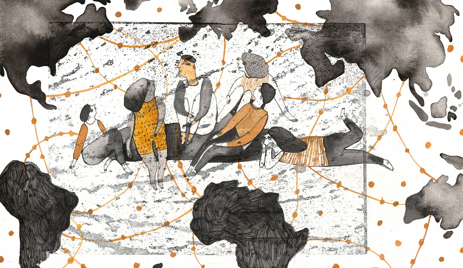
Landscape of Geography
In US Higher Education
Alicia Bradshaw (De Jong)
Background
(This webpage serves as an interactive companion to my capstone paper as partial fulfillment of a Master’s of Science in Geospatial Technologies at the University of Washington Tacoma.)
In recent years, “cartographers” and “specialists in geography” have often been cited as growing occupations in the United States. Responsively, Geography departments in US higher education are appealing to a perceived need for “geographic skills” in the American workforce—specifically for GIS.
With the growth of GIS and workforce demands in mind, this project seeks to portray the modern landscape of higher level Geography in the United States. To do so, it conducts a geographical text analysis of the language used by U.S. Geography departments on their public webpages.
Geographical text analysis combines qualitative and quantitative techniques from corpus linguistics, critical discourse analysis (CDA), and GIS in order to “understand geographical patterns and meanings within text” (Cooper et al, 2015). It draws on the argument that “language is a primary method of communication which allows us to come to a shared understanding of how the world is structured” (Cooper et al, 2015). While geographical text analysis is a relatively novel methodological approach, its interdisciplinary methods help to parse out spatial narratives—such as how GIS is impacting Geography (capitalized in reference to the discipline) departments across the United States.
Creating a Corpus
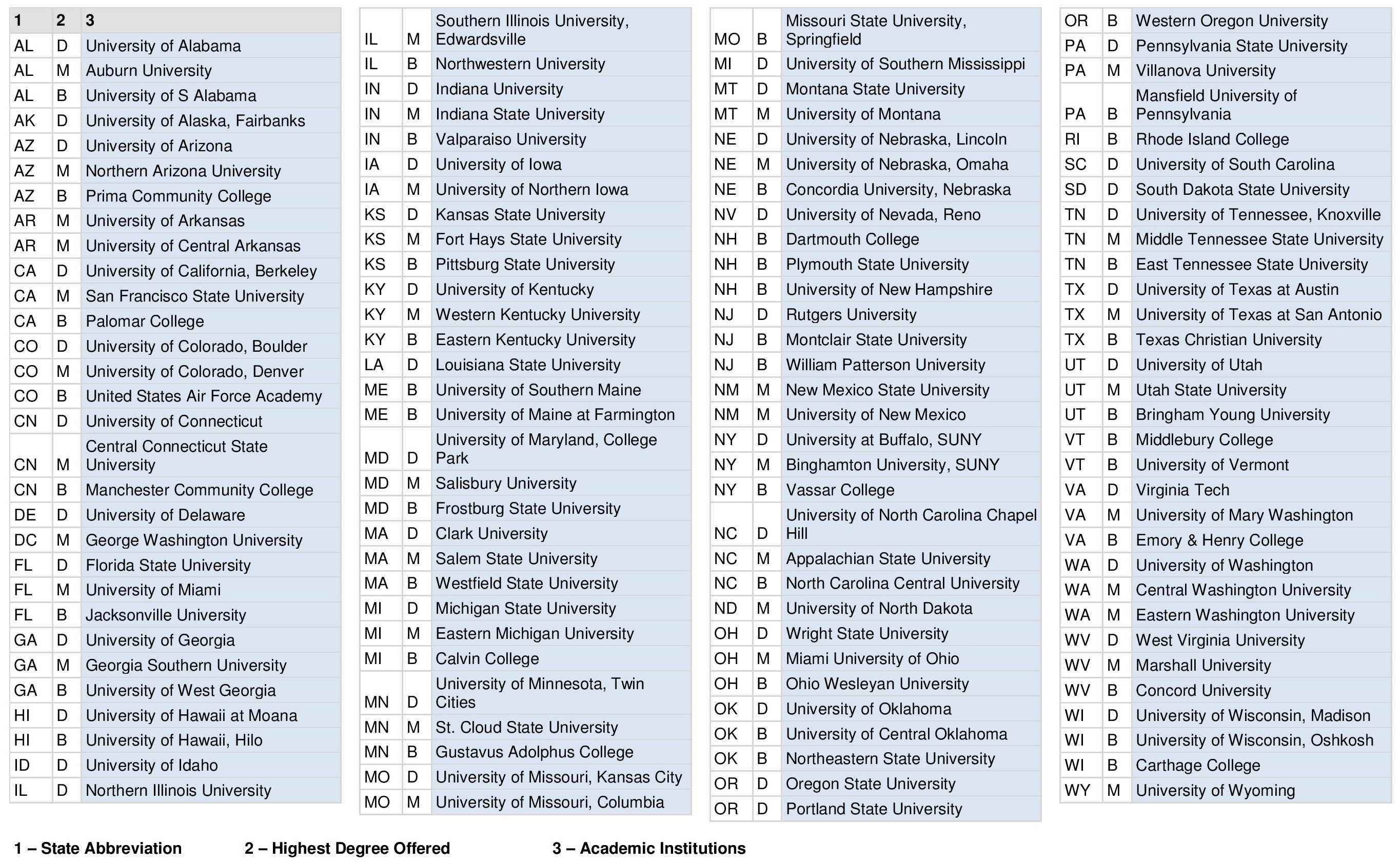
Corpus linguistics is “a methodology used to study language using a large naturally occurring body of text” known as a corpus (Gregory et al, 2015). The corpus for this project consists of 84,084 word tokens gathered from the webpages of across the United States over the month of June 2019. By gathering text related to how departments present themselves and the discipline of Geography to the public, this study is able to analyze differences in how “geography” (lowercase in reference to the search term) and “GIS” are understood and described in higher level education across the country.
In order to parse through the corpus, this project utilized AntConc, a free corpus analysis toolkit. The concordance plot tool was used to search for the frequency of specific words including “geography,” “GIS,” “GIScience,” “geoscience,” and “geospatial.” The “hits,” or number of mentions of the searched word, were recorded for each academic institution in an Excel table. From there, data could be used in spatial analysis.
SPATIAL ANALYSIS
Two calculations—Kernel Density and Multivariate Clustering—were used to map spatial patterns in where “geography” and “GIS” are discussed across the United States. This was carried out using ESRI’s ArcPro Spatial Analyst tools.
Kernel Density
This technique is commonly used in geographical text analysis studies as a way of illustrating concentrations of language use across a geographical area (Patterson & Gregory, 2018)(Gregory et al., 2015). Kernel Density calculates the density of input points by first calculating the probability of density then determining a search radius (ESRI, 2019). In this case, the search radius for points was weighted by frequency of “geography” and “GIS” values respectively.
These Kernel Density maps are a spatial interpolation of where “Geography” and “GIS” are most frequently mentioned across the country.
Geography
GIS
Both words show the highest concentration of mentions in the northeastern United States followed by the Midwest, Pacific Northwest, and southern California. While these regional concentrations are very similar due to the shared location of schools, there are also notable differences.
“Geography” is mentioned in a relatively more dense and even spread across the country. “GIS,” however, is not far behind. This alludes to a growing spread of GIS use in Geography programs across the country. While this trend is not bad, it would be interesting to track if regional language use changes over time. Higher mentions of “GIS” in Geography programs would be highly indicative of the valorization of GIS cautioned by Brown (2004), Smith (1992), Thatcher and Imaoka (2018), and others.
Click on the buttons below to open a map of Kernel Density layers for other words.
Multivariate Clustering
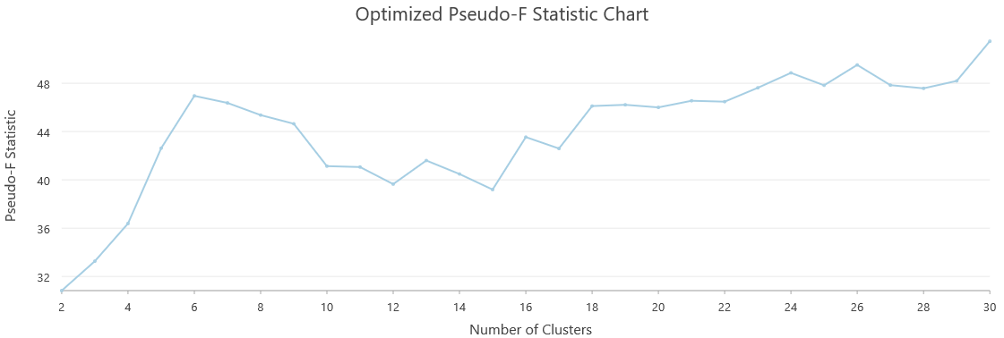
The second spatial analysis utilized ArcPro’s Multivariate Clustering tool in order to visualize non-spatial patterns in language use. Multivariate Clustering uses a K-means algorithm to categorize data into groups with the fewest differences between feature attributes. In this case, clustering was based on each school’s attribute fields for use of the words “geography,” “GIS,” “GIScience,” “geoscience,” and “geospatial.”
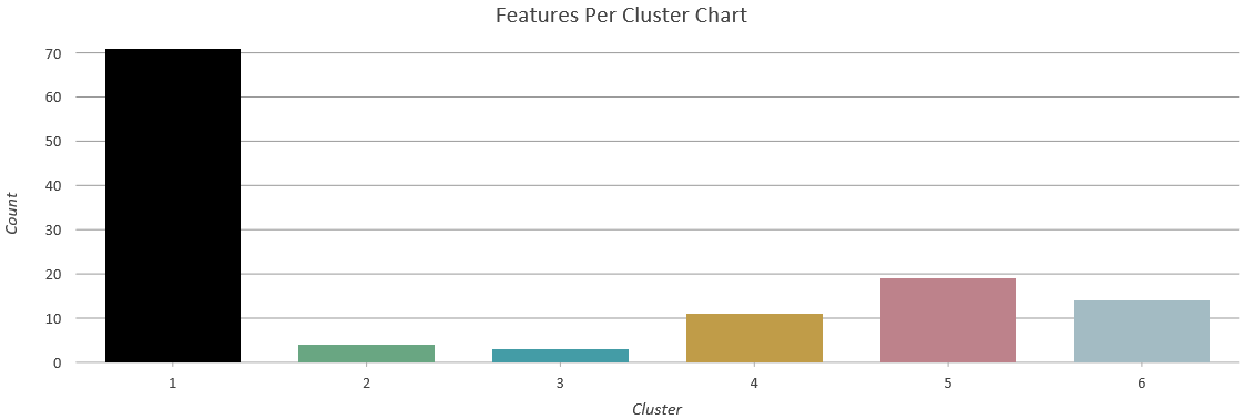
The optimal number of clusters was determined by calculating an optimized . A larger F-statistic indicates “how many clusters will be most effective at distinguishing the features and variables” specified. Although the largest F-statistic for this dataset was 30, the number of clusters used in this analysis is 6 because it was the lowest number of clusters with the highest F-statistic. This allows for easier interpretation of variation between clusters categories.
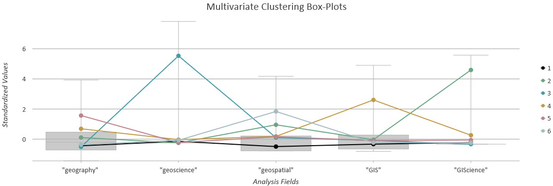
Using this set of , each of the 6 clusters can be characterized in the following way:
Category 1 is the largest category and includes 71 schools from all across the country from Maine and Florida to Washington, California, and Hawaii. Category 5, the second largest category, includes 19 schools that display more frequent mentions of the word “geography.” These schools are also distributed across the country with notable clusters in California, the Midwest, and along the northeast coast.
Overall, this map illustrates a regional variation and inconsistency of language use in Geography departments across the country.
Discourse Analysis
Critical discourse analysis aims to systematically explore how relationships between discourse (in this case, text from Geography departments) and wider social structures, relations, and processes are shaped by relations of power (Fairclough, 1993). This study uses a series of visualizations in order to depict power relations in how Geography departments discuss “geography” and “GIS.”
The first visualization addresses whether there are significant differences in the language used by Geography departments offering different levels of degrees (bachelor’s, master’s, or doctorate). Despite slight differences, language composition remains very similar across all categories and are generally reflective of the corpus as a whole.
These charts illustrate that although language varies regionally, there is some consistency across departments that offer different levels of degrees. Neither "geography" nor "GIS" is priviledged (and therefore afforded power above the other) across these categories of Geography departments.
Click on the chart to see exact quantities.
The second visualization is a series of word clouds comparing which nouns, modifiers (adjectives), and activities (verbs) are used to describe “geography” and “GIS” within the corpus and across the country. These words connote a different pace of urgency between “GIS” and “geography.” It is not hard to imagine that these differences in language hold power to subliminally influence prospective students and decision-makers within academic institutions.
Click on each word to see exact quantities.
Geography Nouns
Most commonly referred to as a “study,” “science,” or, as in the case of this project, a “discipline.”
GIS Nouns
Referred to as a “technology” and “tool.” Frequent use of career-alluding language such as "employment sector", and/or "career path" (not found in reference to “geography”).
Geography Adjectives
Described with moderate positivity (“exciting,” “comprehensive,” “interdisciplinary").
GIS Adjectives
In a 1995 analysis of discourse used to market geographic information systems, Jon Goss refers to this type of language as “technopornography”: “the technical apparatus is eroticized in an aesthetics of power, speed, and control” (Goss, 1995).
Geography Verbs
Much more subdued with words such as “concerned with,” “situated,” “designed,” and “understanding.”
GIS Verbs
“GIS” is “anticipated,” “expected,” “used,” and “expanding.”